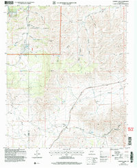
2004 Map of Chimney Lake
USGS Topo · Published 2006About this map
The high Chaves County tablelands meet the Lincoln National Forest in this 2004 revision, where the landscape is defined by an extensive network of ephemeral drainages and stock-rearing infrastructure. The map reveals a pattern of dispersed settlement centered on family-named operations such as McGuire Ranch, Hepler Ranch, and Van Cleve Ranch. These outposts are connected by utilitarian routes like Dunken Road and Wilkerson Road, reflecting the pastoral economy of the Sacramento Mountains foothills.
Find a feature on this map
39 named features on this map. Tap any name to fly to it.
Don’t see what you’re looking for? This feature index may not catch every label — zoom into the map to look around manually.
Map Details
Editions of this 2004 Chimney Lake Map
This is the sole edition of this map. No revisions or reprints were ever made.
Other maps of this area

1954 · Carlsbad
USGS Topo · 1:250,000

1958 · Carlsbad
USGS Topo · 1:250,000

1962 · Dunken
USGS Topo · 1:62,500

1963 · Cornucopia Canyon
USGS Topo · 1:24,000

1963 · Robertson Canyon
USGS Topo · 1:24,000

1963 · Woodson Canyon
USGS Topo · 1:24,000

1965 · Chimney Lake
USGS Topo · 1:24,000

1965 · Lewis Peak
USGS Topo · 1:24,000

1965 · Avis
USGS Topo · 1:24,000

1965 · Pinon
USGS Topo · 1:24,000