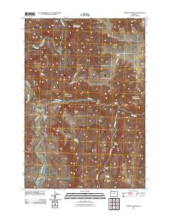
2011 Map of Chimney Springs
USGS Topo · Published 2011About this map
The John Day River carves a deep path through this section of Wasco County, defining a landscape of high plateaus and complex drainage systems. At the center of the sheet, Juniper Flat serves as a prominent landmark between the river and the dissecting canyons to the east. The map records several named water sources vital to the area's geography, including Chimney Springs and East Frickey Spring, which drain into the many canyons like Knox Canyon and Harvey Canyon.
Find a feature on this map
20 named features on this map. Tap any name to fly to it.
Don’t see what you’re looking for? This feature index may not catch every label — zoom into the map to look around manually.
Map Details
Editions of this 2011 Chimney Springs Map
This is the sole edition of this map. No revisions or reprints were ever made.
Other maps of this area

1916 · Condon
USGS Topo · 1:125,000

1926 · Mitchell
USGS Topo · 1:125,000

1953 · The Dalles
USGS Topo · 1:250,000

1955 · Bend
USGS Topo · 1:250,000

1956 · The Dalles
USGS Topo · 1:250,000

1957 · Bend
USGS Topo · 1:250,000

1957 · The Dalles
USGS Topo · 1:250,000

1958 · Bend
USGS Topo · 1:250,000

1966 · Antelope
USGS Topo · 1:62,500

1966 · Clarno
USGS Topo · 1:62,500