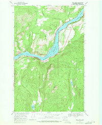
1969 Map of China Bend
USGS Topo · Published 1971About this map
The Columbia River carves a sharp path through Stevens County, defining the corridor of the Coulee Dam National Recreation Area. By the late 1960s, the impounded waters of Franklin D Roosevelt Lake dominate the valley floor, held at a normal pool elevation of 1289 feet. The landscape reflects the industrial and transportation needs of northeastern Washington, where the Burlington Northern railroad follows the eastern riverbank through small settlements like Marble and past the site of China.
Find a feature on this map
25 named features on this map. Tap any name to fly to it.
Don’t see what you’re looking for? This feature index may not catch every label — zoom into the map to look around manually.
Map Details
Editions of this 1969 China Bend Map
2 editions found
Other maps of this area

1929 · Colville
USGS Topo · 1:125,000

1933 · Colville
USGS Topo · 1:125,000

1936 · Marcus
USGS Topo · 1:96,000

1942 · Marcus
USGS Topo · 1:125,000

1948 · Kettle Falls
USGS Topo · 1:62,500

1948 · Orient
USGS Topo · 1:62,500

1951 · Orient
USGS Topo · 1:62,500

1951 · Kettle Falls
USGS Topo · 1:62,500

1952 · Gillette Mtn
USGS Topo · 1:24,000

1952 · Echo Valley
USGS Topo · 1:24,000