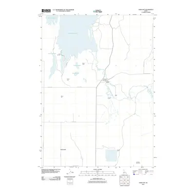
2010 Map of China Hat
USGS Topo · Published 2010About this map
Blackfoot Reservoir dominates the northern landscape of this Caribou County region, where the industrial infrastructure of the China Cap Dam meets a terrain defined by volcanic features and high-elevation ranching. The map document traces the winding path of the Blackfoot River as it moves past the Blackfoot River Park Access Area and under the Blackfoot Bridge. This area is characterized by several distinct peaks including China Hat, China Cap, and Woodall Mountain. Settlement patterns are sparse, represented by family operations like Clements Ranch and Doulls Ranch, alongside the community at Meadowville. Small water bodies such as Gronewell Lake and Burchett Lake sit in the shadow of North Cone, illustrating a quiet, high-desert agricultural and recreational environment.
Find a feature on this map
25 named features on this map. Tap any name to fly to it.
Don’t see what you’re looking for? This feature index may not catch every label — zoom into the map to look around manually.
Map Details
Editions of this 2010 China Hat Map
This is the sole edition of this map. No revisions or reprints were ever made.
Other maps of this area

1911 · Slug Creek
USGS Topo · 1:62,500

1914 · Henry
USGS Topo · 1:48,000

1915 · Lanes Creek
USGS Topo · 1:62,500

1916 · Henry
USGS Topo · 1:62,500

1948 · Soda Springs
USGS Topo · 1:62,500

1949 · Soda Springs
USGS Topo · 1:62,500

1949 · Johnson Creek
USGS Topo · 1:24,000

1949 · Lower Valley
USGS Topo · 1:24,000

1951 · Lower Valley
USGS Topo · 1:24,000
1951 · Johnson Creek
USGS Topo · 1:24,000