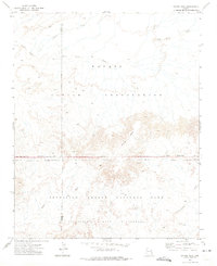
1972 Map of Chinde Mesa
USGS Topo · Published 1975About this map
Chinde Mesa anchors this high-desert landscape in northern Arizona, marking a significant transition between distinct administrative territories. The southern portion of the quadrangle is occupied by Petrified Forest National Park, which includes the designated Petrified Forest Wilderness. This protected area meets the Navajo Indian Reservation along a defined boundary that runs east to west across the center of the sheet. The drainage patterns are a defining characteristic of this arid environment, with the Wide Ruin Wash and Leroux Wash cutting through the terrain. The presence of Lithodendron Wash and Digger Wash further illustrates the complex hydrological network of the Painted Desert region, where seasonal water flow has shaped the colorful geologic formations.
Find a feature on this map
13 named features on this map. Tap any name to fly to it.
Don’t see what you’re looking for? This feature index may not catch every label — zoom into the map to look around manually.
Map Details
Editions of this 1972 Chinde Mesa Map
This is the sole edition of this map. No revisions or reprints were ever made.
Other maps of this area

1886 · Fort Defiance
USGS Topo · 1:250,000

1892 · Fort Defiance
USGS Topo · 1:250,000

1954 · Gallup
USGS Topo · 1:250,000

1958 · Gallup
USGS Topo · 1:250,000

1959 · Gallup
USGS Topo · 1:250,000

1962 · Gallup
USGS Topo · 1:250,000

1967 · Gallup
USGS Topo · 1:250,000
1972 · Little Lithodendron Tank
USGS Topo · 1:24,000
1972 · Pilot Rock
USGS Topo · 1:24,000
1972 · Tanner Springs
USGS Topo · 1:24,000