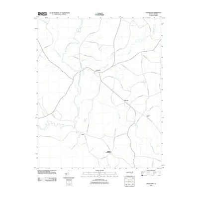
2010 Map of Chinquapin
USGS Topo · Published 2010About this map
The Northeast Cape Fear River meanders through this Duplin County landscape, defining the character of the coastal plain near the settlement of Chinquapin. The map reveals a rural network of family-named roads, such as Myrtle Sholar Rd and Jimmy Tate Williams Rd, which suggest long-standing local lineages and agricultural ties. To the southeast, Maready and Sholars Crossroads serve as secondary hubs, while the Chinquapin Lookout Tower stands as a notable landmark overlooking the convergence of Muddy Creek and Cypress Creek. The transition from the river lowlands to the higher ground near Sloan is evident in the drainage patterns of Stocking Head Creek, illustrating the environmental factors that shaped early homesteading and modern infrastructure in this North Carolina interior.
Find a feature on this map
39 named features on this map. Tap any name to fly to it.
Don’t see what you’re looking for? This feature index may not catch every label — zoom into the map to look around manually.
Map Details
Editions of this 2010 Chinquapin Map
This is the sole edition of this map. No revisions or reprints were ever made.
Other maps of this area

1942 · Burgaw
USGS Topo · 1:62,500

1943 · Kenansville
USGS Topo · 1:62,500

1948 · Kenansville
USGS Topo · 1:62,500

1948 · Maple Hill
USGS Topo · 1:62,500

1948 · Richlands
USGS Topo · 1:62,500

1953 · Beaufort
USGS Topo · 1:250,000

1954 · Beaufort
USGS Topo · 1:250,000

1965 · Richlands
USGS Topo · 1:62,500

1972 · Beaufort
USGS Topo · 1:250,000
1980 · Richlands
USGS Topo · 1:62,500