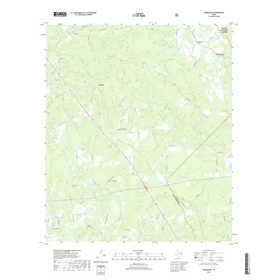
2019 Map of Chinquapin
USGS Topo · Published 2019About this map
The dense East Texas timberlands of the Sabine National Forest dominate the northeastern corner of this area, where the terrain transitions into a complex web of creek drainages. Small settlements like Venable and Fords Corner are connected by a network of rural routes, including FM 1, FM 1751, and FM 3229. For genealogists, the map is particularly detailed regarding local burial sites, documenting Sheffield Cem, Redlands Cem, and the Head Family Cem among several others. These family and community plots are often the primary remaining indicators of earlier rural homesteads. The landscape is defined by its water system, with Chinquapin Cr, Ayish Bayou, and Steep Cr carving through the wooded hills. Civil infrastructure includes the Fairway Farm Airport and a series of well-maintained county roads that navigate the dips of Sixmile Hollow.
Find a feature on this map
59 named features on this map. Tap any name to fly to it.
Don’t see what you’re looking for? This feature index may not catch every label — zoom into the map to look around manually.
Map Details
Editions of this 2019 Chinquapin Map
This is the sole edition of this map. No revisions or reprints were ever made.
Other maps of this area
1944 · Patroon
USGS Topo · 1:62,500

1953 · Alexandria
USGS Topo · 1:250,000

1953 · Palestine
USGS Topo · 1:250,000

1955 · Alexandria
USGS Topo · 1:250,000
1956 · Patroon
USGS Topo · 1:62,500

1957 · Palestine
USGS Topo · 1:250,000
1958 · Hemphill
USGS Topo · 1:62,500
1958 · San Augustine
USGS Topo · 1:62,500
1958 · Bronson
USGS Topo · 1:62,500
1984 · Norwood
USGS Topo · 1:24,000