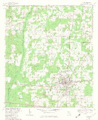
1982 Map of Chipley
USGS Topo · Published 1982About this map
Chipley serves as the focal point of this 1982 revision, situated at the junction of the Louisville and Nashville railroad and major regional thoroughfares. The town's infrastructure is well-defined, showing the hospital, Roulhac Middle Sch, and the Vocational Tech Center. Surrounding the urban center, the landscape is a network of bayous and ponds, such as Wolf Bay, Register Bay, and Watts Pond, which shape the rural settlements of Sand Hill and Bahoma.
Find a feature on this map
53 named features on this map. Tap any name to fly to it.
Don’t see what you’re looking for? This feature index may not catch every label — zoom into the map to look around manually.
Map Details
Editions of this 1982 Chipley Map
This is the sole edition of this map. No revisions or reprints were ever made.
Other maps of this area

1950 · Chipley
USGS Topo · 1:24,000

1950 · Wausau
USGS Topo · 1:24,000

1950 · Esto
USGS Topo · 1:24,000

1950 · Poplar Head
USGS Topo · 1:24,000

1951 · Graceville
USGS Topo · 1:24,000

1951 · Esto
USGS Topo · 1:24,000

1951 · Chipley
USGS Topo · 1:24,000

1951 · Wausau
USGS Topo · 1:24,000
1951 · Poplar Head
USGS Topo · 1:24,000

1951 · Bonifay
USGS Topo · 1:24,000