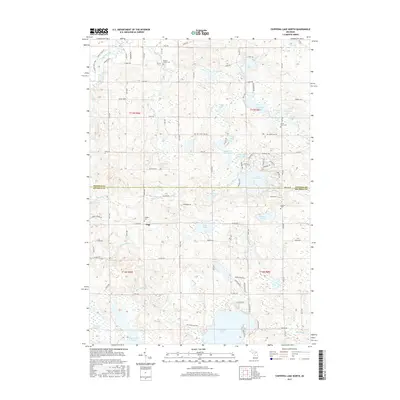
2017 Map of Chippewa Lake North
USGS Topo · Published 2017About this map
The small settlement of Pogy serves as a central landmark in this 2017 survey of the borderlands between Osceola and Mecosta counties. This glacial landscape is defined by an intricate network of kettle lakes and streams, including the prominent Chippewa Lake at the southern edge and the residential developments surrounding Lake Miramichi. For genealogists, the map provides precise locations for several burial grounds, such as the Proctor Family Cem and the Pioneer Cem near Pogy. The terrain transitions from the wetland complexes of Featherbed Marsh and Haymarsh Lakes in the southwest to the winding path of the Muskegon River in the northwest corner. A grid of rural roads like Mecola Rd and Big Stone Lake Rd connects these scattered water bodies, showing the modern parceling of timber and farmland around Pogy Lake and Pitcher Lake.
Find a feature on this map
63 named features on this map. Tap any name to fly to it.
Don’t see what you’re looking for? This feature index may not catch every label — zoom into the map to look around manually.
Map Details
Editions of this 2017 Chippewa Lake North Map
This is the sole edition of this map. No revisions or reprints were ever made.
Other maps of this area

1954 · Midland
USGS Topo · 1:250,000

1958 · Midland
USGS Topo · 1:250,000

1958 · Big Rapids
USGS Topo · 1:62,500

1959 · Midland
USGS Topo · 1:250,000

1959 · Lake
USGS Topo · 1:62,500

1959 · Evart
USGS Topo · 1:62,500

1964 · Mecosta NW
USGS Topo · 1:24,000

1966 · Midland
USGS Topo · 1:250,000

1976 · Evart SW
USGS Topo · 1:24,000
1976 · Big Rapids NW
USGS Topo · 1:24,000