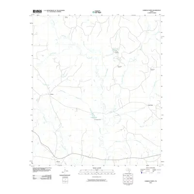
2010 Map of Chireno North
USGS Topo · Published 2010About this map
The Attoyac River creates a meandering central corridor through this portion of Nacogdoches County, shaping a landscape defined by seasonal drainages and small-scale water management. This 2010 data captures a rural Texas environment where localized landmarks like the Pat Scoggins Dam on Scoggins Lake and the Spring Lake Dam regulate the flow of creeks into the river system. The map reveals a pattern of long-established community anchors, notably the cluster of burial grounds including Holmes Cemetery, Spring Ridge Cemetery, and Gethsemane Cemetery, which serve as vital touchstones for family history in the area.
Find a feature on this map
22 named features on this map. Tap any name to fly to it.
Don’t see what you’re looking for? This feature index may not catch every label — zoom into the map to look around manually.
Map Details
Editions of this 2010 Chireno North Map
This is the sole edition of this map. No revisions or reprints were ever made.
Other maps of this area

1953 · Palestine
USGS Topo · 1:250,000

1957 · Palestine
USGS Topo · 1:250,000

1958 · Broaddus
USGS Topo · 1:62,500

1958 · San Augustine
USGS Topo · 1:62,500

1958 · Martinsville
USGS Topo · 1:62,500

1958 · Bronson
USGS Topo · 1:62,500

1984 · Norwood
USGS Topo · 1:24,000
1984 · Etoile North
USGS Topo · 1:24,000
1984 · Chireno South
USGS Topo · 1:24,000

1984 · Palestine
USGS Topo · 1:250,000