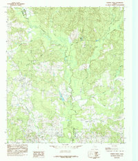
1984 Map of Chireno North
USGS Topo · Published 1985About this map
The Attoyac River meanders south through the center of this East Texas terrain, forming the natural boundary between Nacogdoches County and San Augustine County. In the early 1980s, this landscape is defined by its complex drainage network, where backwaters like Tupelo Slough, Gum Slough, and Scoggins Lake fill the lowlands. Near the southern margin, the community of Chireno serves as a local hub, with nearby sites like a local Cemetery and various creek crossings marking the rural settlement pattern.
Find a feature on this map
19 named features on this map. Tap any name to fly to it.
Don’t see what you’re looking for? This feature index may not catch every label — zoom into the map to look around manually.
Map Details
Editions of this 1984 Chireno North Map
This is the sole edition of this map. No revisions or reprints were ever made.
Other maps of this area

1953 · Palestine
USGS Topo · 1:250,000

1957 · Palestine
USGS Topo · 1:250,000

1958 · Broaddus
USGS Topo · 1:62,500

1958 · San Augustine
USGS Topo · 1:62,500

1958 · Martinsville
USGS Topo · 1:62,500

1958 · Bronson
USGS Topo · 1:62,500

1984 · Norwood
USGS Topo · 1:24,000
1984 · Etoile North
USGS Topo · 1:24,000
1984 · Chireno South
USGS Topo · 1:24,000

1984 · Palestine
USGS Topo · 1:250,000