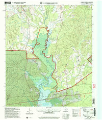
2003 Map of Chireno South
USGS Topo · Published 2004About this map
The Attoyac River serves as the central geographic feature and county boundary on this 2003 survey, flowing south through the Angelina National Forest into the northern reaches of the Sam Rayburn Reservoir. The settlement of Chireno sits at the northern edge, surrounded by a complex network of drainage basins including Pollygot Creek and Amaladeros Creek. The landscape reflects a mix of public forest lands and established rural communities, with clear markings for the National Forest Boundary as it stood in the early 21st century.
Find a feature on this map
33 named features on this map. Tap any name to fly to it.
Don’t see what you’re looking for? This feature index may not catch every label — zoom into the map to look around manually.
Map Details
Editions of this 2003 Chireno South Map
This is the sole edition of this map. No revisions or reprints were ever made.
Other maps of this area

1953 · Palestine
USGS Topo · 1:250,000

1957 · Palestine
USGS Topo · 1:250,000

1958 · Broaddus
USGS Topo · 1:62,500

1958 · San Augustine
USGS Topo · 1:62,500

1958 · Martinsville
USGS Topo · 1:62,500

1958 · Bronson
USGS Topo · 1:62,500

1984 · Norwood
USGS Topo · 1:24,000
1984 · Etoile North
USGS Topo · 1:24,000
1984 · Chireno South
USGS Topo · 1:24,000
1984 · Harvey Creek
USGS Topo · 1:24,000