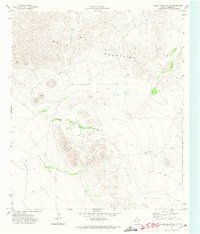
1972 Map of Chispa Mountain NW
USGS Topo · Published 1974About this map
The Wylie Mountains dominate this Trans-Pecos landscape as it appeared in the early 1970s, showcasing the stark topography of West Texas. This 1972 survey, field-checked by the Geological Survey and the Texas Water Development Board, reveals a desert environment where water sources are vital but sparse. Evidence of human activity is primarily limited to various instances of a Well or Tank scattered across the basin floors, indicating a reliance on groundwater for ranching or local survival. To the west, the Lobo Valley transitions into a significant Depression, while a pair of isolated Landing Strips provides a link to more distant settlements. The map illustrates a remote terrain where the physical geography dictating land use remains largely unchanged from the mid-century era.
Find a feature on this map
6 named features on this map. Tap any name to fly to it.
Don’t see what you’re looking for? This feature index may not catch every label — zoom into the map to look around manually.
Map Details
Editions of this 1972 Chispa Mountain NW Map
This is the sole edition of this map. No revisions or reprints were ever made.
Other maps of this area

1892 · Chispa
USGS Topo · 1:125,000

1895 · Chispa
USGS Topo · 1:125,000

1897 · Chispa
USGS Topo · 1:125,000

1906 · Van Horn
USGS Topo · 1:125,000

1954 · Van Horn
USGS Topo · 1:250,000

1958 · Van Horn
USGS Topo · 1:250,000

1959 · Marfa
USGS Topo · 1:250,000

1964 · Wild Horse
USGS Topo · 1:24,000

1964 · Van Horn
USGS Topo · 1:24,000
1964 · Plateau
USGS Topo · 1:24,000