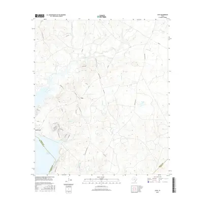
2016 Map of Chita
USGS Topo · Published 2016About this map
Chita sits at the center of this rural Trinity County landscape, defined by its intricate network of winding creeks and proximity to the eastern shores of Lake Livingston. The area around Sebastopol reveals a shift toward modern residential development with subdivisions like Shadywood and Cedar Creek appearing near the waterfront. Away from the lake, the terrain remains deeply rooted in local traditions, evidenced by the Sulphur Cr Hunting Club Rd and several family-named landmarks like Haynes Lake. This map provides significant genealogical value through its clear identification of local transit routes such as Chita Cemetery Rd and Carlisle Chita Cemetery Rd, which connect the small settlement centers to their respective burial grounds. The drainage pattern is exceptionally detailed, tracing the flow of Caney Creek, Sulphur Cr, and Brushy Cr as they move through the undulating Texas Piney Woods environment.
Find a feature on this map
47 named features on this map. Tap any name to fly to it.
Don’t see what you’re looking for? This feature index may not catch every label — zoom into the map to look around manually.
Map Details
Editions of this 2016 Chita Map
This is the sole edition of this map. No revisions or reprints were ever made.
Other maps of this area

1953 · Palestine
USGS Topo · 1:250,000

1954 · Beaumont
USGS Topo · 1:250,000

1957 · Beaumont
USGS Topo · 1:250,000

1957 · Palestine
USGS Topo · 1:250,000
1960 · Colita
USGS Topo · 1:24,000
1960 · Trinity East
USGS Topo · 1:24,000
1960 · Carlisle
USGS Topo · 1:24,000
1961 · Staley
USGS Topo · 1:24,000
1961 · Onalaska
USGS Topo · 1:24,000
1962 · Glendale
USGS Topo · 1:24,000