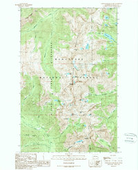
1989 Map of Chiwaukum Mountains
USGS Topo · Published 1989About this map
The Chiwaukum Mountains dominate this high-elevation landscape, where deep glacial basins and sharp ridgelines define the interior of the Wenatchee National Forest. This 1989 provisional survey captures the transition between the Alpine Lakes Wilderness and the surrounding forest lands, focusing on the intricate hydrology of the region. A dense network of high-country lakes, including the cluster around Loch Eileen, Lake Donald, and Lake Ethel, feed into drainage systems like Whitepine Creek and the South Fork Chiwaukum Creek. The geography is characterized by prominent divides such as Icicle Ridge and Mc Cue Ridge, which separate the rugged valleys. For researchers, the map provides a clear record of established access routes during the late 1980s, including numerous Pack Trails and a Footbridge over Icicle Creek, essential for navigating the complex terrain between Snowgrass Mountain and the southern slopes of Grindstone Mountain.
Find a feature on this map
52 named features on this map. Tap any name to fly to it.
Don’t see what you’re looking for? This feature index may not catch every label — zoom into the map to look around manually.
Map Details
Editions of this 1989 Chiwaukum Mountains Map
2 editions found
Other maps of this area

1901 · Chiwaukum
USGS Topo · 1:125,000

1902 · Skykomish
USGS Topo · 1:125,000

1904 · Chiwaukum
USGS Topo · 1:125,000

1905 · Skykomish
USGS Topo · 1:125,000

1957 · Wenatchee
USGS Topo · 1:250,000

1965 · Chiwaukum Mts
USGS Topo · 1:62,500

1965 · Stevens Pass
USGS Topo · 1:24,000

1965 · Wenatchee Lake
USGS Topo · 1:62,500
1965 · The Cradle
USGS Topo · 1:24,000
1965 · Labyrinth Mtn
USGS Topo · 1:24,000