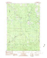
1982 Map of Choate
USGS Topo · Published 1983About this map
The Ottawa National Forest dominates this northern Michigan landscape, where the confluence of several major river branches dictates the terrain. The South Branch Ontonagon River and the Cisco Branch Ontonagon River wind through the timberlands, marked by water features like Eighteen Mile Rapids and the drop at Wolverine Falls. This 1980s-era survey reveals a topography heavily influenced by former industrial activity and forest management.
Find a feature on this map
22 named features on this map. Tap any name to fly to it.
Don’t see what you’re looking for? This feature index may not catch every label — zoom into the map to look around manually.
Map Details
Editions of this 1982 Choate Map
This is the sole edition of this map. No revisions or reprints were ever made.
Other maps of this area

1949 · Rockland
USGS Topo · 1:62,500

1951 · Rockland
USGS Topo · 1:62,500

1952 · Watersmeet
USGS Topo · 1:62,500

1952 · Thayer
USGS Topo · 1:62,500

1956 · Matchwood
USGS Topo · 1:62,500

1958 · Iron River
USGS Topo · 1:250,000

1960 · Iron River
USGS Topo · 1:250,000

1961 · Iron River
USGS Topo · 1:250,000

1967 · Iron River
USGS Topo · 1:250,000

1979 · Ontonagon
USGS Topo · 1:100,000
Featured Places
- Marenisco Township, MI
- McMillan Township, MI
- Haight Township, MI
- Gogebic County, MI
- Ontonagon County, MI