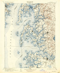
1908 Map of Choptank
USGS Topo · Published 1934About this map
Annapolis and its storied U S Naval Academy overlook the mouth of the Severn River, anchoring the northwestern corner of this intricate maritime survey. The landscape is defined by the deep indentations of the Chesapeake Bay, where the Choptank River, Miles River, and Wye River create a complex network of peninsulas and necks. This era captures the region's reliance on both rail and water transport, evidenced by the Baltimore and Chesapeake Atlantic RR terminating near Claiborne, a vital ferry link to the western shore. Inland, the market town of Easton serves as a hub for agricultural settlements like Wye Mills and Longwoods. Coastal life is centered around oyster and fishing ports such as St Michaels and Oxford, while the many points and coves like Bloody Pt and Tolly Pt underscore the prominence of navigation in early 20th-century Maryland life.
Find a feature on this map
161 named features on this map. Tap any name to fly to it.
Don’t see what you’re looking for? This feature index may not catch every label — zoom into the map to look around manually.
Map Details
Editions of this 1908 Choptank Map
5 editions found

Other maps of this area

1892 · Leonardtown
USGS Topo · 1:62,500

1892 · Drum Point
USGS Topo · 1:62,500

1892 · Prince Frederick
USGS Topo · 1:62,500

1892 · Owensville
USGS Topo · 1:62,500

1892 · Annapolis
USGS Topo · 1:62,500

1893 · Sharps Island
USGS Topo · 1:62,500

1893 · North Point
USGS Topo · 1:62,500

1894 · Relay
USGS Topo · 1:62,500

1895 · Prince Frederick
USGS Topo · 1:62,500

1895 · Leonardtown
USGS Topo · 1:62,500