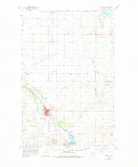
1960 Map of Choteau
USGS Topo · Published 1975About this map
The Teton River and Muddy Creek converge in this high plains landscape of north-central Montana, where water management and agriculture define the local economy. The town of Choteau serves as a vital hub, located near the junction of the Great Northern and the Chicago Milwaukee St Paul and Pacific railroads. The map highlights the extensive network of irrigation infrastructure, including the Eldorado Ditch, Farmers Ditch, and Teton Ditch, which support the grain elevators seen at Agawam and Malone.
Find a feature on this map
53 named features on this map. Tap any name to fly to it.
Don’t see what you’re looking for? This feature index may not catch every label — zoom into the map to look around manually.
Map Details
Editions of this 1960 Choteau Map
2 editions found

Other maps of this area

1886 · Great Falls
USGS Topo · 1:250,000

1920 · Choteau
USGS Topo · 1:125,000

1920 · Dupuyer
USGS Topo · 1:125,000

1920 · Conrad
USGS Topo · 1:125,000

1936 · Pendroy
USGS Topo · 1:48,000

1938 · Gallup City
USGS Topo · 1:62,500

1941 · Pendroy
USGS Topo · 1:62,500

1942 · Gallup City
USGS Topo · 1:62,500

1950 · Fairfield
USGS Topo · 1:62,500

1950 · Collins
USGS Topo · 1:62,500