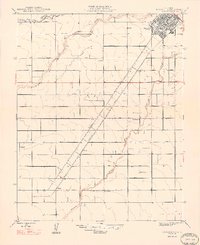
1948 Map of Chowchilla
USGS Topo · Published 1948About this map
Chowchilla serves as the primary hub in this agricultural landscape of the late 1940s, situated just south of the Chowchilla River and the county line between Merced and Madera. The town is anchored by the Southern Pacific Boulevard, which cuts a diagonal line across the grid of family-named thoroughfares. This network of roads, including Grant Road, Washington Road, and Jefferson Road, reflects a highly organized rural development pattern typical of the San Joaquin Valley.
Find a feature on this map
27 named features on this map. Tap any name to fly to it.
Don’t see what you’re looking for? This feature index may not catch every label — zoom into the map to look around manually.
Map Details
Editions of this 1948 Chowchilla Map
2 editions found
Other maps of this area

1916 · Berenda
USGS Topo · 1:31,680

1918 · Bliss Ranch
USGS Topo · 1:31,680

1918 · Lingard
USGS Topo · 1:31,680

1918 · Chowchilla
USGS Topo · 1:31,680

1918 · Berenda
USGS Topo · 1:31,680

1918 · La Grand
USGS Topo · 1:31,680

1919 · Plainsberg
USGS Topo · 1:31,680

1920 · Bonita Ranch
USGS Topo · 1:31,680

1921 · Bonita Ranch
USGS Topo · 1:31,680

1922 · Pozo Farm
USGS Topo · 1:31,680