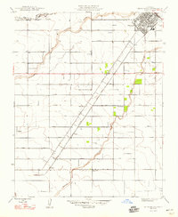
1948 Map of Chowchilla
USGS Topo · Published 1948About this map
Chowchilla serves as the hub of this Central Valley agricultural landscape, situated at the intersection of the Southern Pacific railroad and the diagonal corridor of Robertson Boulevard. The 1946 revision captures a highly structured rural grid defined by roads named for American presidents, including Washington Road and Jefferson Road. This systematic layout reflects the intensive irrigation and settlement patterns of the era, where small rural centers like Tillman, Dairyland, and Lincoln supported the surrounding farmstead operations.
Find a feature on this map
27 named features on this map. Tap any name to fly to it.
Don’t see what you’re looking for? This feature index may not catch every label — zoom into the map to look around manually.
Map Details
Editions of this 1948 Chowchilla Map
2 editions found
Other maps of this area

1916 · Berenda
USGS Topo · 1:31,680

1918 · Bliss Ranch
USGS Topo · 1:31,680

1918 · Lingard
USGS Topo · 1:31,680

1918 · Chowchilla
USGS Topo · 1:31,680

1918 · Berenda
USGS Topo · 1:31,680

1918 · La Grand
USGS Topo · 1:31,680

1919 · Plainsberg
USGS Topo · 1:31,680

1920 · Bonita Ranch
USGS Topo · 1:31,680

1921 · Bonita Ranch
USGS Topo · 1:31,680

1922 · Pozo Farm
USGS Topo · 1:31,680