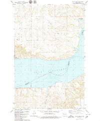
1979 Map of Chris Creek
USGS Topo · Published 1979About this map
Lake Sakakawea and the submerged channel of the Missouri River dominate this landscape, reflecting the massive hydrological changes of the mid-20th century. By the late 1970s, the reservoirs' reach is fully established, bordering Lewis and Clark State Park and the youth camp at Camp Cherith. These waters reshaped the bottomlands where Twin Valley and several named creeks once ran.
Find a feature on this map
16 named features on this map. Tap any name to fly to it.
Don’t see what you’re looking for? This feature index may not catch every label — zoom into the map to look around manually.
Map Details
Editions of this 1979 Chris Creek Map
This is the sole edition of this map. No revisions or reprints were ever made.
Other maps of this area

1911 · Ray
USGS Topo · 1:125,000

1953 · Williston
USGS Topo · 1:250,000

1953 · Watford City
USGS Topo · 1:250,000

1957 · Williston
USGS Topo · 1:250,000

1957 · Watford City
USGS Topo · 1:250,000

1967 · Watford City
USGS Topo · 1:250,000

1969 · Cussicks Spring
USGS Topo · 1:24,000

1978 · Lake Jessie
USGS Topo · 1:24,000

1978 · Watford City NW
USGS Topo · 1:24,000

1978 · Watford City NE
USGS Topo · 1:24,000