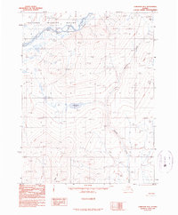
1990 Map of Christian B-5
USGS Topo · Published 1990About this map
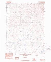
The Arctic National Wildlife Refuge dominates the northern landscape of this interior Alaska region, where the East Fork Chandalar River carves a winding path through high-altitude terrain. This 1990 provisional survey documents a largely roadless wilderness characterized by significant elevation changes and seasonal access routes. A solitary Winter Trail in the northeastern corner and a handful of other unnamed trails provide the only terrestrial evidence of human transit through the mountains. The drainage patterns are defined by the southward flow of Kocacho Creek and the presence of high-latitude water bodies like Tsyooktuihvun Lake, which rests in a central basin. The map illustrates a moment in late 20th-century conservation history, marking official wildlife refuge boundaries across a landscape where traditional winter travel remained a primary means of navigation.
Find a feature on this map
10 named features on this map. Tap any name to fly to it.
Don’t see what you’re looking for? This feature index may not catch every label — zoom into the map to look around manually.
Map Details
Editions of this 1990 Christian B-5 Map
This is the sole edition of this map. No revisions or reprints were ever made.
Other maps of this area

1951 · Christian
USGS Topo · 1:250,000

1956 · Christian
USGS Topo · 1:250,000
1990 · Christian C-4
USGS Topo · 1:63,360
1990 · Christian C-6
USGS Topo · 1:63,360
1990 · Christian B-6
USGS Topo · 1:63,360
1990 · Christian A-6
USGS Topo · 1:63,360
1990 · Christian C-5
USGS Topo · 1:63,360
1990 · Christian A-5
USGS Topo · 1:63,360
1990 · Christian A-4
USGS Topo · 1:63,360
1990 · Christian B-4
USGS Topo · 1:63,360