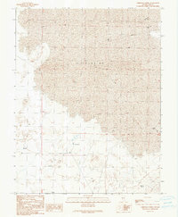
1990 Map of Christian Spring
USGS Topo · Published 1990About this map
The vast, arid expanses of Nye County are defined by groundwater resources and geological curiosities in this late 20th-century survey. A massive central Depression dominates the landscape, suggesting the complex basin-and-range topography characteristic of this region. Human activity is evidenced by a network of 4wd tracks and several exploratory Drill Holes, indicating mineral or resource investigation in this high desert environment. Water remains the primary focal point for survival and navigation, with named sites such as Christian Spring and various unnamed Springs providing rare lifeblood to the area. The presence of a Flowing Well and several other wells further marks the strategic importance of tapping into the subterranean aquifers. This map provides a clear record of the intersection between harsh terrain and the necessary infrastructure required to explore and inhabit it.
Find a feature on this map
11 named features on this map. Tap any name to fly to it.
Don’t see what you’re looking for? This feature index may not catch every label — zoom into the map to look around manually.
Map Details
Editions of this 1990 Christian Spring Map
This is the sole edition of this map. No revisions or reprints were ever made.
Other maps of this area

1956 · Lund
USGS Topo · 1:250,000

1960 · Lund
USGS Topo · 1:250,000

1964 · Blue Eagle Springs
USGS Topo · 1:62,500

1964 · Troy Canyon
USGS Topo · 1:62,500

1968 · Portuguese Mtn
USGS Topo · 1:62,500

1968 · The Wall
USGS Topo · 1:62,500
1968 · The Wall SE
USGS Topo · 1:24,000
1968 · Lockes
USGS Topo · 1:24,000
1968 · The Wall NE
USGS Topo · 1:24,000

1980 · Duckwater
USGS Topo · 1:100,000