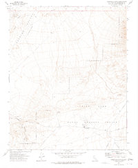
1973 Map of Christmas Canyon
USGS Topo · Published 1975About this map
China Lake Naval Weapons Center dominates the southern half of this desert landscape, characterized by restricted zones and military infrastructure like the Randsburg Wash Headquarters. In the early 1970s, this area of San Bernardino County served as a critical testing and research corridor, as evidenced by the numerous Radio Towers and specialized Restricted Access Roads crossing the terrain. The northern portion transitions into the Searles Valley (Depression), where the drainage of Teagle Wash flows toward The Pinnacles. Traces of earlier human activity are visible in the clusters of Prospects and Gravel Pits located near Christmas Canyon, while a network of primitive routes like the Jeep Trail provides the only access through the higher elevations. The map effectively captures the tension between the vast natural basin and the structured, indefinite boundaries of the mid-century defense industry.
Find a feature on this map
16 named features on this map. Tap any name to fly to it.
Don’t see what you’re looking for? This feature index may not catch every label — zoom into the map to look around manually.
Map Details
Editions of this 1973 Christmas Canyon Map
3 editions found
Other maps of this area

1915 · Searles Lake
USGS Topo · 1:250,000

1947 · Trona
USGS Topo · 1:250,000

1948 · Trona
USGS Topo · 1:250,000

1949 · Searles Lake
USGS Topo · 1:62,500

1950 · Searles Lake
USGS Topo · 1:62,500

1950 · Wingate Pass
USGS Topo · 1:62,500

1951 · Wingate Pass
USGS Topo · 1:62,500

1953 · Trona
USGS Topo · 1:250,000

1954 · Pilot Knob
USGS Topo · 1:62,500

1954 · Cuddeback Lake
USGS Topo · 1:62,500