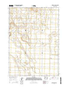
2014 Map of Christmas Lake
USGS Topo · Published 2014About this map
Christmas Lake Valley sits at the heart of this high desert landscape in Lake County, Oregon. The area is defined by its arid basin topography, where the seasonal waters of Christmas Lake and the prominent rising profile of Bunchgrass Butte dominate the horizon. This 2014 survey documents the grid of agricultural and residential roads that serve the basin, including many named for local geography or early land use, such as Rock House Rd and Oster Farm Rd. The map also traces the Christmas Valley Back Country Bywy, a route designed for exploring the unique geological and ecological features of this part of the Oregon Outback. Traces of historical land management are evident in the township and range boundaries, which segment the territory into expansive sections between corridors like Lost Forest Ln and Fossil Lake Rd.
Find a feature on this map
27 named features on this map. Tap any name to fly to it.
Don’t see what you’re looking for? This feature index may not catch every label — zoom into the map to look around manually.
Map Details
Editions of this 2014 Christmas Lake Map
This is the sole edition of this map. No revisions or reprints were ever made.
Other maps of this area

1955 · Crescent
USGS Topo · 1:250,000

1957 · Crescent
USGS Topo · 1:250,000

1958 · Crescent
USGS Topo · 1:250,000

1970 · Crescent
USGS Topo · 1:250,000

1981 · Fossil Lake
USGS Topo · 1:24,000

1981 · Mean Rock Well
USGS Topo · 1:24,000

1982 · Peters Creek Sink
USGS Topo · 1:24,000

1982 · Christmas Lake
USGS Topo · 1:24,000

1982 · Jacks Place
USGS Topo · 1:24,000
1983 · Crack-in-the-Ground
USGS Topo · 1:24,000