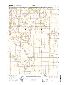
2017 Map of Christmas Lake
USGS Topo · Published 2017About this map
Christmas Lake and the surrounding Christmas Lake Valley form the heart of this high-desert landscape in central Oregon. The terrain is defined by its wide, flat basins and isolated rises such as Bunchgrass Butte in the north. This 2017 survey reveals a grid of rural routes and family-named roads that crisscross the valley floor, hinting at the agricultural and ranching legacy of the region. Notable corridors include Fossil Lake Rd and Stonehouse Rd, which connect the scattered properties across the sagebrush-covered plains. The presence of Lost Forest Ln points toward the unique Ponderosa pine grove found just beyond the map's eastern edge, while the playa of Christmas Lake itself serves as a central landmark for this arid environment.
Find a feature on this map
28 named features on this map. Tap any name to fly to it.
Don’t see what you’re looking for? This feature index may not catch every label — zoom into the map to look around manually.
Map Details
Editions of this 2017 Christmas Lake Map
This is the sole edition of this map. No revisions or reprints were ever made.
Other maps of this area

1955 · Crescent
USGS Topo · 1:250,000

1957 · Crescent
USGS Topo · 1:250,000

1958 · Crescent
USGS Topo · 1:250,000

1970 · Crescent
USGS Topo · 1:250,000

1981 · Fossil Lake
USGS Topo · 1:24,000

1981 · Mean Rock Well
USGS Topo · 1:24,000

1982 · Peters Creek Sink
USGS Topo · 1:24,000

1982 · Christmas Lake
USGS Topo · 1:24,000

1982 · Jacks Place
USGS Topo · 1:24,000
1983 · Crack-in-the-Ground
USGS Topo · 1:24,000