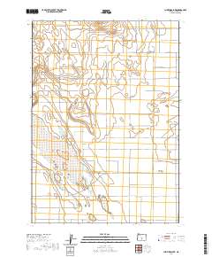
2020 Map of Christmas Lake
USGS Topo · Published 2020About this map
Christmas Lake Valley and the dry basin of Christmas Lake anchor this high-desert landscape in central Oregon. The terrain is defined by its isolation and the stark contrast between the flat alkali beds and prominent rises like Bunchgrass Butte. This 2020 survey illustrates a grid of remote roads that facilitate access to this unique geological region, including Millican Rd, Lost Forest Ln, and Stonehouse Rd. The naming conventions of the local thoroughfares, such as Desert View Ln and Fossil Lake Rd, reflect the environmental character and paleontological significance of the surrounding Lake County backcountry. The map also delineates the complex township and range boundaries that have governed land management in this arid expanse since the original land surveys.
Find a feature on this map
28 named features on this map. Tap any name to fly to it.
Don’t see what you’re looking for? This feature index may not catch every label — zoom into the map to look around manually.
Map Details
Editions of this 2020 Christmas Lake Map
This is the sole edition of this map. No revisions or reprints were ever made.
Other maps of this area

1955 · Crescent
USGS Topo · 1:250,000

1957 · Crescent
USGS Topo · 1:250,000

1958 · Crescent
USGS Topo · 1:250,000

1970 · Crescent
USGS Topo · 1:250,000

1981 · Fossil Lake
USGS Topo · 1:24,000

1981 · Mean Rock Well
USGS Topo · 1:24,000

1982 · Peters Creek Sink
USGS Topo · 1:24,000

1982 · Christmas Lake
USGS Topo · 1:24,000

1982 · Jacks Place
USGS Topo · 1:24,000
1983 · Crack-in-the-Ground
USGS Topo · 1:24,000