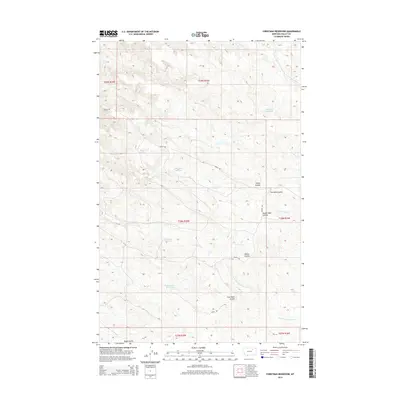
2014 Map of Christmas Reservoir
USGS Topo · Published 2014About this map
Christmas Reservoir sits at the heart of this Valley County landscape, surrounded by an intricate system of catchments and coulees that define the local ranching and water management patterns of the early 21st century. The map reveals a network of small, named water bodies such as Pippin Reservoir, Ear-Nuff Reservoir, and the curiously named Trailerhouse Reservoir, which suggest the vital importance of water storage in this semi-arid region. These features are linked by a sparse road system including S Bench Rd and Pippin Rd. The topography is etched with numerous coulees, such as South Shed Coulee and Coal Bank Coulee, which channel drainage toward the N Fork Little Beaver Cr. This survey illustrates the localized naming conventions used by land managers and residents, from Pot Hole Coulee to Whites Coulee, providing a clear record of the area's geographic identity before modern shifts in land use or climate.
Find a feature on this map
23 named features on this map. Tap any name to fly to it.
Don’t see what you’re looking for? This feature index may not catch every label — zoom into the map to look around manually.
Map Details
Editions of this 2014 Christmas Reservoir Map
This is the sole edition of this map. No revisions or reprints were ever made.
Other maps of this area

1954 · Glasgow
USGS Topo · 1:250,000

1957 · Glasgow
USGS Topo · 1:250,000

1958 · Glasgow
USGS Topo · 1:250,000
1984 · Hardpan Coulee
USGS Topo · 1:24,000
1984 · Burnett Flats West
USGS Topo · 1:24,000
1984 · Burnett Flats East
USGS Topo · 1:24,000

1984 · Ashford Coulee
USGS Topo · 1:24,000
1984 · Craig Reservoir
USGS Topo · 1:24,000
1984 · Flat Coulee
USGS Topo · 1:24,000
1984 · Christmas Reservoir
USGS Topo · 1:24,000