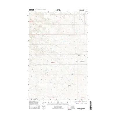
2017 Map of Christmas Reservoir
USGS Topo · Published 2017About this map
Christmas Reservoir serves as a central landmark in this portion of the Montana high plains, where the landscape is defined by an intricate network of drainage coulees and small-scale water management. The terrain is deeply incised by seasonal waterways including Coal Bank Coulee, Whites Coulee, and Home Coulee, which feed into larger systems like the N Fork Little Beaver Cr. This 2017 survey illustrates the continued reliance on scattered reservoirs for livestock and land management, with interestingly named features such as Far-Nuff Reservoir, Trailerhouse Reservoir, and Pippin Reservoir punctuating the vast rangeland. Transportation is limited to a few arterial routes like Skyview Ridge Rd and S Bench Rd, tracing the higher ground above the drainages. The map reveals the persistent checkerboard pattern of the Public Land Survey System, spanning several townships such as t28n r35e, and underscores the isolation and utilitarian character of this rural Valley County region.
Find a feature on this map
22 named features on this map. Tap any name to fly to it.
Don’t see what you’re looking for? This feature index may not catch every label — zoom into the map to look around manually.
Map Details
Editions of this 2017 Christmas Reservoir Map
This is the sole edition of this map. No revisions or reprints were ever made.
Other maps of this area

1954 · Glasgow
USGS Topo · 1:250,000

1957 · Glasgow
USGS Topo · 1:250,000

1958 · Glasgow
USGS Topo · 1:250,000
1984 · Hardpan Coulee
USGS Topo · 1:24,000
1984 · Burnett Flats West
USGS Topo · 1:24,000
1984 · Burnett Flats East
USGS Topo · 1:24,000

1984 · Ashford Coulee
USGS Topo · 1:24,000
1984 · Craig Reservoir
USGS Topo · 1:24,000
1984 · Flat Coulee
USGS Topo · 1:24,000
1984 · Christmas Reservoir
USGS Topo · 1:24,000