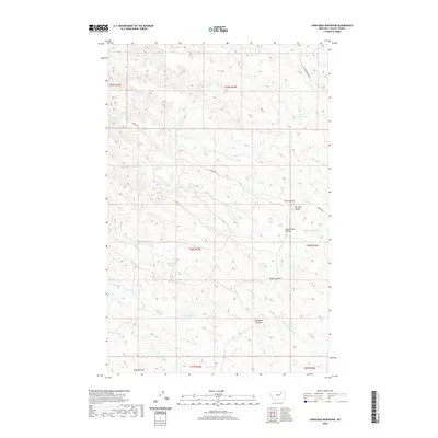
2020 Map of Christmas Reservoir
USGS Topo · Published 2020About this map
The dry-land ranching and water management systems of Valley County are central to this 2020 map. The landscape is defined by a complex network of coulees—seasonal drainage channels—including Home Coulee, Whites Coulee, and the curiously named Pot Hole Coulee. These features highlight the natural erosion patterns of the Montana plains, where water is a scarce and precious resource. Human intervention is evident through numerous small-scale impoundments such as Christmas Reservoir, Horace Reservoir, and the humorously titled Far-Nuff Reservoir. These reservoirs, along with Trailerhouse Reservoir, likely serve as stock ponds for cattle, reflecting the area's agricultural reliance on capturing run-off. Transportation is limited to remote routes like Skyview Ridge Rd and S Bench Rd, which navigate the high ground between the drainage basins of Brazil Cr and N Fork Little Beaver Cr.
Find a feature on this map
23 named features on this map. Tap any name to fly to it.
Don’t see what you’re looking for? This feature index may not catch every label — zoom into the map to look around manually.
Map Details
Editions of this 2020 Christmas Reservoir Map
This is the sole edition of this map. No revisions or reprints were ever made.
Other maps of this area

1954 · Glasgow
USGS Topo · 1:250,000

1957 · Glasgow
USGS Topo · 1:250,000

1958 · Glasgow
USGS Topo · 1:250,000
1984 · Hardpan Coulee
USGS Topo · 1:24,000
1984 · Burnett Flats West
USGS Topo · 1:24,000
1984 · Burnett Flats East
USGS Topo · 1:24,000

1984 · Ashford Coulee
USGS Topo · 1:24,000
1984 · Craig Reservoir
USGS Topo · 1:24,000
1984 · Flat Coulee
USGS Topo · 1:24,000
1984 · Christmas Reservoir
USGS Topo · 1:24,000