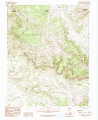
1983 Map of Chromo Mountain
USGS Topo · Published 1983About this map
The Continental Divide zigzags across this high-altitude landscape along the border of Colorado and New Mexico, marking the hydrologic backbone of the region. Much of the southern and eastern portions of the map fall within the expansive Tierra Amarilla Grant, a massive historic land tract that shapes the local geography. High peaks and deep incisions like Tuck Canyon define the terrain, while the Rio Chamita drains the eastern slopes. This 1983 survey records a landscape dominated by water and relief, featuring numerous named drainages such as Amargo Creek and Estufa Creek, alongside isolated high-country waters like Beaver Lake and Las Ranas Lake. The map provides a detailed look at the interface between Archuleta County, Colorado, and Rio Arriba County, New Mexico, during the early 1980s.
Find a feature on this map
21 named features on this map. Tap any name to fly to it.
Don’t see what you’re looking for? This feature index may not catch every label — zoom into the map to look around manually.
Map Details
Editions of this 1983 Chromo Mountain Map
2 editions found
Other maps of this area

1913 · Summitville
USGS Topo · 1:125,000

1915 · Summitville
USGS Topo · 1:125,000

1945 · Durango
USGS Topo · 1:250,000

1953 · Durango
USGS Topo · 1:250,000

1954 · Durango
USGS Topo · 1:250,000

1954 · Aztec
USGS Topo · 1:250,000

1955 · Chama
USGS Topo · 1:62,500

1955 · Lumberton
USGS Topo · 1:62,500

1957 · Chromo
USGS Topo · 1:62,500

1957 · Chama Peak
USGS Topo · 1:62,500