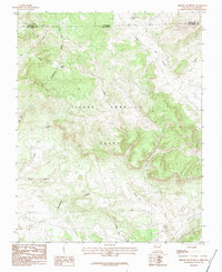
1983 Map of Chromo Mountain
USGS Topo · Published 1983About this map
The Tierra Amarilla Grant dominates this 1983 survey of the high country along the Colorado and New Mexico border. Situated along the Continental Divide, the landscape is defined by the massive Chromo Mountain and the headwaters of several drainages, including Rio Chamita and Willow Creek. Historical industrial activity is evidenced by the Old RR Grade winding through the southern portion of the quadrangle, a remnant of former transportation networks in this high-altitude region. Engineering from the later 20th century is also visible with the inclusion of the Azotea Tunnel. Smaller landmarks such as Clydes Corral Lake and Las Ranas Lake provide specific points of reference for those tracing early land use and topography within the Rio Arriba and Archuleta county lines.
Find a feature on this map
27 named features on this map. Tap any name to fly to it.
Don’t see what you’re looking for? This feature index may not catch every label — zoom into the map to look around manually.
Map Details
Editions of this 1983 Chromo Mountain Map
2 editions found
Other maps of this area

1913 · Summitville
USGS Topo · 1:125,000

1915 · Summitville
USGS Topo · 1:125,000

1945 · Durango
USGS Topo · 1:250,000

1953 · Durango
USGS Topo · 1:250,000

1954 · Durango
USGS Topo · 1:250,000

1954 · Aztec
USGS Topo · 1:250,000

1955 · Chama
USGS Topo · 1:62,500

1955 · Lumberton
USGS Topo · 1:62,500

1957 · Chromo
USGS Topo · 1:62,500

1957 · Chama Peak
USGS Topo · 1:62,500