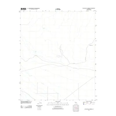
2012 Map of Chuckwalla Spring
USGS Topo · Published 2012About this map
The Bradshaw Trl and Butterfield Trl converge in this arid corridor of Imperial County, marking two of the most significant historic overland routes through the California desert. The landscape is defined by the braided drainage of Arroyo Seco, which cuts through the basin toward the elevated terrain of Graham Pass. These trails served as vital arteries for mid-19th-century gold seekers and stagecoaches, relying on intermittent water sources such as Chuckwalla Spring and Mesquito Spring. Modern access is represented by Niland Rd and Graham Pass Rd, which follow the natural contours and established pathways of earlier pioneers. This map provides a contemporary record of these ancient transit corridors, showing how the local topography dictated the movement of people and commerce between the Colorado River and the coastal settlements.
Find a feature on this map
8 named features on this map. Tap any name to fly to it.
Don’t see what you’re looking for? This feature index may not catch every label — zoom into the map to look around manually.
Map Details
Editions of this 2012 Chuckwalla Spring Map
This is the sole edition of this map. No revisions or reprints were ever made.
Other maps of this area

1940 · Iris Pass
USGS Topo · 1:62,500

1944 · Chuckwalla Mountains
USGS Topo · 1:62,500

1945 · Iris Pass
USGS Topo · 1:62,500

1952 · Sidewinder Well
USGS Topo · 1:62,500

1953 · Chuckwalla Spring
USGS Topo · 1:62,500

1954 · Salton Sea
USGS Topo · 1:250,000

1955 · Salton Sea
USGS Topo · 1:250,000

1959 · Salton Sea
USGS Topo · 1:250,000

1963 · Salton Sea
USGS Topo · 1:250,000
1963 · Iris Pass
USGS Topo · 1:62,500