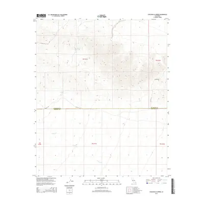
2015 Map of Chuckwalla Spring
USGS Topo · Published 2015About this map
Chuckwalla Spring sits at the heart of this desert landscape, where the shifting elevations of the Chuckwalla Mountains meet the border between Riverside and Imperial counties. The map documents a critical corridor of desert travel, most notably the historic Bradshaw Trl, which runs west-to-east across the lower sections of the survey. This route was famously used as a stagecoach line in the mid-19th century, connecting the Gold Rush fields to the Colorado River. North of this trail, the terrain climbs toward Graham Pass and Augustine Pass Rd, marking the natural bottlenecks through the mountains. Water sources like Mesquite Spring and the drainage of the Arroyo Seco define the geography, highlighting the essential points of relief in an otherwise arid environment where the township and range lines of the Public Land Survey System overlay a complex topography of ridges and dry washes.
Find a feature on this map
13 named features on this map. Tap any name to fly to it.
Don’t see what you’re looking for? This feature index may not catch every label — zoom into the map to look around manually.
Map Details
Editions of this 2015 Chuckwalla Spring Map
This is the sole edition of this map. No revisions or reprints were ever made.
Other maps of this area

1940 · Iris Pass
USGS Topo · 1:62,500

1944 · Chuckwalla Mountains
USGS Topo · 1:62,500

1945 · Iris Pass
USGS Topo · 1:62,500

1952 · Sidewinder Well
USGS Topo · 1:62,500

1953 · Chuckwalla Spring
USGS Topo · 1:62,500

1954 · Salton Sea
USGS Topo · 1:250,000

1955 · Salton Sea
USGS Topo · 1:250,000

1959 · Salton Sea
USGS Topo · 1:250,000

1963 · Salton Sea
USGS Topo · 1:250,000
1963 · Iris Pass
USGS Topo · 1:62,500