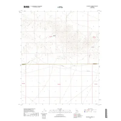
2018 Map of Chuckwalla Spring
USGS Topo · Published 2018About this map
Chuckwalla Spring and Mesquite Spring serve as critical water points in this arid expanse of the Chuckwalla Mountains. This desert landscape is defined by its transit history, particularly where the The Bradshaw Trl and Butterfield Trl intersect the boundary between Riverside and Imperial counties. These routes follow natural corridors through the terrain, such as the opening at Graham Pass, which provided essential passage for early travelers across the southern California desert. The drainage of Arroyo Seco underscores the seasonal hydrology that shaped movement through these canyons. Local access is further detailed by established tracks like Niland Rd and Graham Pass Rd, which provide a modern window into the remote survey lines and historical trail segments that have guided navigation through this region for generations.
Find a feature on this map
15 named features on this map. Tap any name to fly to it.
Don’t see what you’re looking for? This feature index may not catch every label — zoom into the map to look around manually.
Map Details
Editions of this 2018 Chuckwalla Spring Map
This is the sole edition of this map. No revisions or reprints were ever made.
Other maps of this area

1940 · Iris Pass
USGS Topo · 1:62,500

1944 · Chuckwalla Mountains
USGS Topo · 1:62,500

1945 · Iris Pass
USGS Topo · 1:62,500

1952 · Sidewinder Well
USGS Topo · 1:62,500

1953 · Chuckwalla Spring
USGS Topo · 1:62,500

1954 · Salton Sea
USGS Topo · 1:250,000

1955 · Salton Sea
USGS Topo · 1:250,000

1959 · Salton Sea
USGS Topo · 1:250,000

1963 · Salton Sea
USGS Topo · 1:250,000
1963 · Iris Pass
USGS Topo · 1:62,500