1994 Map of Chumuckla
USGS Topo · Published 1998About this map
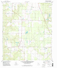
Chumuckla serves as the focal point of this rural panhandle landscape, which is defined by its deep-seated community institutions and agricultural infrastructure. The settlement is anchored by the Chumuckla Sch, Chumuckla Cem, and Chumuckla Ch, illustrating a classic Florida crossroads development pattern. Significant land use is dedicated to the Univ of Florida Agricultural Research Center in the eastern portion of the quadrangle, highlighting the region's importance to state-level agronomic study.
Find a feature on this map
21 named features on this map. Tap any name to fly to it.
Don’t see what you’re looking for? This feature index may not catch every label — zoom into the map to look around manually.
Map Details
Editions of this 1994 Chumuckla Map
This is the sole edition of this map. No revisions or reprints were ever made.
Other maps of this area

1920 · Milton
USGS Topo · 1:62,500

1921 · Muscogee
USGS Topo · 1:62,500

1941 · Muscogee
USGS Topo · 1:62,500

1941 · Milton
USGS Topo · 1:62,500

1941 · Century
USGS Topo · 1:62,500

1943 · Muscogee
USGS Topo · 1:62,500

1943 · Century
USGS Topo · 1:62,500

1943 · Milton
USGS Topo · 1:62,500

1943 · Jay
USGS Topo · 1:62,500

1957 · Pensacola
USGS Topo · 1:250,000