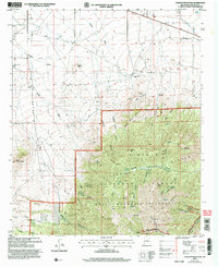
2004 Map of Church Mountain
USGS Topo · Published 2006About this map
White Mountain Wilderness and the Lincoln National Forest dominate this section of the Sierra Blanca range, where high-altitude terrain meets the drainage systems of the arid lowlands. The 2004 revision reflects a landscape transition from the isolated Diamond Peak Ranch and dispersed ranching infrastructure like Harkey Windmill and City Windmill to the protected peaks of Church Mountain and Diamond Peak. Water sources are critical identifiers in this environment, with numerous family-named canyons such as Sanders Canyon and Chaves Canyon providing clues to early settlement patterns. This survey illustrates how natural resources dictated the human footprint, from small-scale Mina operations to the established network of trails and roads that follow seasonal flows like Nogal Creek and the Arroyo Tortolita.
Find a feature on this map
41 named features on this map. Tap any name to fly to it.
Don’t see what you’re looking for? This feature index may not catch every label — zoom into the map to look around manually.
Map Details
Editions of this 2004 Church Mountain Map
This is the sole edition of this map. No revisions or reprints were ever made.
Other maps of this area

1934 · Capitan
USGS Topo · 1:48,000

1937 · Capitan
USGS Topo · 1:62,500

1938 · Carrizozo
USGS Topo · 1:48,000

1943 · Carrizozo
USGS Topo · 1:62,500

1950 · Carrizozo
USGS Topo · 1:62,500

1950 · Sierra Blanca Peak
USGS Topo · 1:62,500

1955 · Roswell
USGS Topo · 1:250,000

1958 · Roswell
USGS Topo · 1:250,000

1962 · Roswell
USGS Topo · 1:250,000

1963 · Angus
USGS Topo · 1:24,000