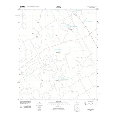
2010 Map of Church Peak
USGS Topo · Published 2010About this map
Church Peak and a series of prominent elevations including Hylton Mountain and Cedar Mountain define this Taylor County landscape. The terrain is deeply influenced by water management, featuring numerous reservoirs such as Soil Conservation Service Site 1 Reservoir and several estate-named lakes, including Odom Currie Wylie Estate Lake Number 1. This 2010 survey highlights the rural industrial footprint of the region through the Fort Chadbourne Oil Field, illustrating the economic reliance on natural resources. The drainage patterns of Fish Creek, Williams Branch, and Wagon Tire Creek connect these high points to the low-lying basins and managed reservoirs, while a network of county roads provides access through the various gaps and mountains.
Find a feature on this map
28 named features on this map. Tap any name to fly to it.
Don’t see what you’re looking for? This feature index may not catch every label — zoom into the map to look around manually.
Map Details
Editions of this 2010 Church Peak Map
This is the sole edition of this map. No revisions or reprints were ever made.
Other maps of this area

1891 · Hayrick
USGS Topo · 1:125,000

1893 · Sweetwater
USGS Topo · 1:125,000

1894 · Hayrick
USGS Topo · 1:125,000

1921 · Bronte
USGS Topo · 1:31,680

1954 · Big Spring
USGS Topo · 1:250,000

1954 · San Angelo
USGS Topo · 1:250,000

1958 · San Angelo
USGS Topo · 1:250,000

1958 · Big Spring
USGS Topo · 1:250,000
1961 · Hog Mountain
USGS Topo · 1:24,000
1961 · Bronte
USGS Topo · 1:24,000