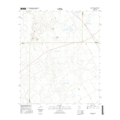
2016 Map of Church Peak
USGS Topo · Published 2016About this map
Church Peak stands as a prominent landmark in this West Texas landscape where the borders of Nolan, Taylor, Coke, and Runnels counties converge. The terrain is defined by a series of distinct mesas and elevations, including Hylton Mtn, Cedar Mtn, and Mathis Mtn, separated by low-lying areas like Dry Hollow. Water management is central to the land use shown here, evidenced by several Soil Conservation Service reservoirs and the large private impoundments of the Odom Currie Wylie Estate Lake Number 1 and Odom Currie Wylie Estate Lake Number 2. These water features serve a network of seasonal drainages such as Wagon Tire Cr and Williams Br. The map reveals a rural infrastructure of farm-to-market roads and ranch trails that navigate the complex topography of Cedar Gap and the surrounding highlands.
Find a feature on this map
37 named features on this map. Tap any name to fly to it.
Don’t see what you’re looking for? This feature index may not catch every label — zoom into the map to look around manually.
Map Details
Editions of this 2016 Church Peak Map
This is the sole edition of this map. No revisions or reprints were ever made.
Other maps of this area

1891 · Hayrick
USGS Topo · 1:125,000

1893 · Sweetwater
USGS Topo · 1:125,000

1894 · Hayrick
USGS Topo · 1:125,000

1921 · Bronte
USGS Topo · 1:31,680

1954 · Big Spring
USGS Topo · 1:250,000

1954 · San Angelo
USGS Topo · 1:250,000

1958 · San Angelo
USGS Topo · 1:250,000

1958 · Big Spring
USGS Topo · 1:250,000
1961 · Hog Mountain
USGS Topo · 1:24,000
1961 · Bronte
USGS Topo · 1:24,000