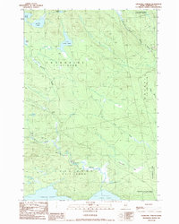
1989 Map of Churchill Stream
USGS Topo · Published 1989About this map
Long Pond anchors the southern reaches of this Maine landscape, where the waters of Churchill Stream and Barton Brook converge. This 1989 provisional study documents the vast wetland systems and timberlands of Somerset County, defined largely by unorganized territories and grants such as Thorndike, Soldiertown, and the Sandwich Academy Grant. The terrain is defined by its complex hydrology, with isolated waters like Luther Pond, Muskrat Pond, and Fish Pond interspersed among private woods roads. A few Gravel Pits indicate localized extraction activity, while the eastern edge is dominated by the sprawling Twelvemile Bog. The map illustrates a remote working forest before modern development, tracing the paths of the South Branch Brassua Stream and Stony Brook as they navigate the basin.
Find a feature on this map
22 named features on this map. Tap any name to fly to it.
Don’t see what you’re looking for? This feature index may not catch every label — zoom into the map to look around manually.
Map Details
Editions of this 1989 Churchill Stream Map
This is the sole edition of this map. No revisions or reprints were ever made.
Other maps of this area

1921 · Brassua Lake
USGS Topo · 1:62,500

1922 · Long Pond
USGS Topo · 1:62,500

1923 · Brassua Lake
USGS Topo · 1:62,500

1924 · Long Pond
USGS Topo · 1:62,500

1944 · Brassua Lake
USGS Topo · 1:62,500

1944 · Long Pond
USGS Topo · 1:62,500

1949 · Jackman
USGS Topo · 1:250,000

1954 · Seboomook Lake
USGS Topo · 1:62,500

1954 · Millinocket
USGS Topo · 1:250,000

1956 · Penobscot Lake
USGS Topo · 1:62,500
Featured Places
- Sandwich Academy Grant Township, ME
- Long Pond Township, ME
- Thorndike Township, ME
- Brassua Township, ME
- Soldiertown Township, ME