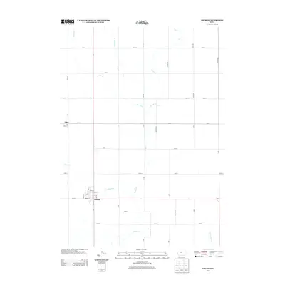
2013 Map of Churdan
USGS Topo · Published 2013About this map
Churdan and the small community of Adaza anchor this Greene County landscape, illustrating the classic grid-iron settlement pattern of rural Iowa. The terrain is defined by the winding course of Hardin Cr and its tributaries, including Reading Cr and the aptly named Happy Run. These waterways break the straight-line geometry of the section roads, such as York Ave and Zearing Ave, which carve the prairie into precise agricultural blocks. The inclusion of Ditch Number 28 points to the systematic drainage efforts required to transform this region into productive farmland. Within the town limits of Churdan, a dense network of residential streets like Beecher St, Harding St, and Sand St reveals the organized layout of this local hub at the start of the 21st century.
Find a feature on this map
45 named features on this map. Tap any name to fly to it.
Don’t see what you’re looking for? This feature index may not catch every label — zoom into the map to look around manually.
Map Details
Editions of this 2013 Churdan Map
This is the sole edition of this map. No revisions or reprints were ever made.
Other maps of this area

1954 · Fort Dodge
USGS Topo · 1:250,000

1957 · Fort Dodge
USGS Topo · 1:250,000

1958 · Fort Dodge
USGS Topo · 1:250,000

1962 · Jefferson
USGS Topo · 1:62,500

1965 · Farnhamville
USGS Topo · 1:24,000

1965 · Gowrie
USGS Topo · 1:24,000

1980 · Wightman
USGS Topo · 1:24,000
1980 · Scranton
USGS Topo · 1:24,000
1980 · Lohrville
USGS Topo · 1:24,000
1985 · Carroll
USGS Topo · 1:100,000