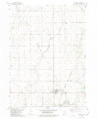
1980 Map of Lohrville
USGS Topo · Published 1980About this map
Lohrville stands as a rail junction in the southern Calhoun County landscape, where the Chicago and North Western and the Chicago Milwaukee St Paul and Pacific lines intersect. The map illustrates a strictly organized agricultural grid across Logan, Union, and Reading townships, interrupted only by the winding course of Purgatory Creek and West Cedar Creek. Smaller rail stop communities like Piper to the north and Rands to the northwest reflect the era's dependence on rail for moving grain and goods.
Find a feature on this map
24 named features on this map. Tap any name to fly to it.
Don’t see what you’re looking for? This feature index may not catch every label — zoom into the map to look around manually.
Map Details
Editions of this 1980 Lohrville Map
This is the sole edition of this map. No revisions or reprints were ever made.
Other maps of this area

1954 · Fort Dodge
USGS Topo · 1:250,000

1957 · Fort Dodge
USGS Topo · 1:250,000

1958 · Fort Dodge
USGS Topo · 1:250,000

1962 · Jefferson
USGS Topo · 1:62,500

1965 · Farnhamville
USGS Topo · 1:24,000

1965 · Knierim
USGS Topo · 1:24,000

1980 · Rockwell City
USGS Topo · 1:24,000

1980 · Wightman
USGS Topo · 1:24,000
1980 · Lanesboro
USGS Topo · 1:24,000
1980 · Richard
USGS Topo · 1:24,000