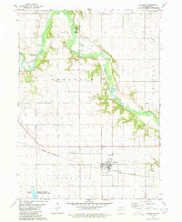
1980 Map of Scranton
USGS Topo · Published 1980About this map
The North Raccoon River winds through the northern half of this Greene County landscape, creating a wooded corridor that contrasts with the surrounding agricultural grid. Near its banks, local recreational and social hubs include Hyde County Park, which features a boat ramp and ski lift, and the Raccoon River Bible Camp. The town of Scranton serves as the primary settlement, positioned along the Chicago and North Western railroad. This rail line was central to the region's development, facilitating the movement of grain and goods from the local elevators.
Find a feature on this map
22 named features on this map. Tap any name to fly to it.
Don’t see what you’re looking for? This feature index may not catch every label — zoom into the map to look around manually.
Map Details
Editions of this 1980 Scranton Map
This is the sole edition of this map. No revisions or reprints were ever made.
Other maps of this area

1954 · Bagley
USGS Topo · 1:62,500

1954 · Omaha
USGS Topo · 1:250,000

1954 · Fort Dodge
USGS Topo · 1:250,000

1957 · Omaha
USGS Topo · 1:250,000

1957 · Fort Dodge
USGS Topo · 1:250,000

1958 · Omaha
USGS Topo · 1:250,000

1958 · Fort Dodge
USGS Topo · 1:250,000

1962 · Jefferson
USGS Topo · 1:62,500

1971 · Coon Rapids NE
USGS Topo · 1:24,000

1971 · Coon Rapids North
USGS Topo · 1:24,000