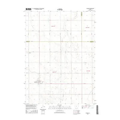
2015 Map of Churdan
USGS Topo · Published 2015About this map
Churdan and the smaller settlement of Adaza anchor this central Iowa landscape, positioned at the intersection of Calhoun, Webster, and Greene Counties. The terrain is defined by a complex network of agricultural drainage and natural waterways, including Hardin Cr, Reading Cr, and the specifically identified Ditch Number 28. These features reflect the systematic management of the prairie for intensive farming. Local history and genealogy are anchored at Highland Cem, located just east of the Churdan town site. The grid-like road system, with named thoroughfares such as Waukon Ave and Zearing Ave, highlights the highly organized township structure of the mid-2010s, while smaller streams like Happy Run continue to carve through the expansive fields of the Iowa plains.
Find a feature on this map
52 named features on this map. Tap any name to fly to it.
Don’t see what you’re looking for? This feature index may not catch every label — zoom into the map to look around manually.
Map Details
Editions of this 2015 Churdan Map
This is the sole edition of this map. No revisions or reprints were ever made.
Other maps of this area

1954 · Fort Dodge
USGS Topo · 1:250,000

1957 · Fort Dodge
USGS Topo · 1:250,000

1958 · Fort Dodge
USGS Topo · 1:250,000

1962 · Jefferson
USGS Topo · 1:62,500

1965 · Farnhamville
USGS Topo · 1:24,000

1965 · Gowrie
USGS Topo · 1:24,000

1980 · Wightman
USGS Topo · 1:24,000
1980 · Scranton
USGS Topo · 1:24,000
1980 · Lohrville
USGS Topo · 1:24,000
1985 · Carroll
USGS Topo · 1:100,000