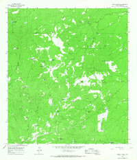
1965 Map of Cibolo Ranch
USGS Topo · Published 1967About this map
Cibolo Ranch and its surrounding rangeland in Webb County define this mid-1960s landscape, where water management was the primary driver of human activity. The map reveals a sophisticated network of artificial catchments and reservoirs vital for livestock in this semi-arid environment, including named features like Las Tijeras Tank, Kuykendall Tank, and the Blind Trap Tank. These landmarks, along with family-named sites such as Juan De Leon Well and De Cavazos Tank, provide significant clues for genealogists tracking South Texas land-use history and ranching families.
Find a feature on this map
28 named features on this map. Tap any name to fly to it.
Don’t see what you’re looking for? This feature index may not catch every label — zoom into the map to look around manually.
Map Details
Editions of this 1965 Cibolo Ranch Map
2 editions found
Other maps of this area

1937 · Aguilete Creek
USGS Topo · 1:62,500

1956 · Becerra
USGS Topo · 1:62,500

1956 · Laredo East
USGS Topo · 1:62,500

1956 · Webb
USGS Topo · 1:62,500

1956 · Laredo
USGS Topo · 1:250,000

1965 · Orvil
USGS Topo · 1:24,000

1965 · Cibolo Ranch
USGS Topo · 1:24,000

1965 · Tios Creek
USGS Topo · 1:24,000

1965 · Laredo East
USGS Topo · 1:24,000
1980 · Callaghan Ranch SE
USGS Topo · 1:24,000