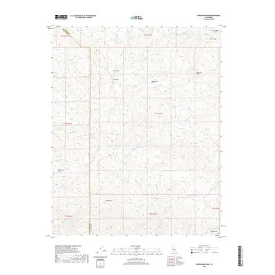
2018 Map of Ciervo Mountain
USGS Topo · Published 2018About this map
Ciervo Mtn and the Ciervo Hills dominate this portion of the Diablo Range, marking the rugged transition toward the western edge of the San Joaquin Valley. This 2018 survey highlights a landscape defined by sharp elevation changes and seasonal watercourses, where deep canyons like Arroyo Hondo, Arroyo Venado, and Arroyo Leona carve through the arid terrain. The map documents vital water sources in this dry environment, including Ciervo Spring, Borreguero Spring, and Harris Spring. Along the eastern boundary, Monocline Ridge provides a distinct geological border overlooking the Central Valley. Evidence of historic land use and boundary divisions is clear through the Township and Range lines and the San Carlos Bolsa area, illustrating the intersection of natural topography and administrative surveying in Fresno and San Benito counties.
Find a feature on this map
26 named features on this map. Tap any name to fly to it.
Don’t see what you’re looking for? This feature index may not catch every label — zoom into the map to look around manually.
Map Details
Editions of this 2018 Ciervo Mountain Map
This is the sole edition of this map. No revisions or reprints were ever made.
Other maps of this area

1912 · Coalinga
USGS Topo · 1:125,000

1913 · Panoche
USGS Topo · 1:125,000

1915 · Priest Valley
USGS Topo · 1:125,000

1923 · Levis
USGS Topo · 1:31,680

1923 · Monocline Ridge
USGS Topo · 1:31,680

1943 · New Idria
USGS Topo · 1:62,500

1943 · Joaquin Rocks
USGS Topo · 1:62,500

1946 · Tranquillity
USGS Topo · 1:62,500
1947 · Levis
USGS Topo · 1:24,000

1948 · Santa Cruz
USGS Topo · 1:250,000