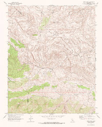
1969 Map of Ciervo Mtn.
USGS Topo · Published 1972About this map
Ciervo Mountain and the prominent Monocline Ridge dominate this late-1960s landscape along the boundary of Fresno and San Benito Counties. This arid, high-elevation terrain is defined by a complex network of seasonal watercourses and remote springs that supported the region's ranching economy. Significant drainage systems such as Arroyo Hondo and Cantua Creek carve through the foothills, while isolated water sources like Borreguero Spring and Harris Spring provided essential stopovers for movement through the hills.
Find a feature on this map
17 named features on this map. Tap any name to fly to it.
Don’t see what you’re looking for? This feature index may not catch every label — zoom into the map to look around manually.
Map Details
Editions of this 1969 Ciervo Mtn. Map
2 editions found
Other maps of this area

1912 · Coalinga
USGS Topo · 1:125,000

1913 · Panoche
USGS Topo · 1:125,000

1915 · Priest Valley
USGS Topo · 1:125,000

1923 · Levis
USGS Topo · 1:31,680

1923 · Monocline Ridge
USGS Topo · 1:31,680

1943 · New Idria
USGS Topo · 1:62,500

1943 · Joaquin Rocks
USGS Topo · 1:62,500

1946 · Tranquillity
USGS Topo · 1:62,500
1947 · Levis
USGS Topo · 1:24,000

1948 · Santa Cruz
USGS Topo · 1:250,000