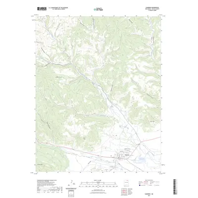
2023 Map of Cimarron
USGS Topo · Published 2023About this map
Cimarron sits at the confluence of several major canyon systems where the Cimarron River meets the plains of northeastern New Mexico. The landscape is defined by its transition from high terrain like Antelope Mesa and Slate Hill into the deep drainage basins of Ponil Creek and its many tributaries, including South Ponil Creek and North Ponil Creek. This 2023 survey illustrates the modern layout of the settlement, showing residential streets such as Maxwell Blvd and Pinon Ave alongside historical landmarks like the Chase Ranch Cem. The convergence of numerous trails, including the Dean Trl and Mcbride Trl, suggests a geography deeply shaped by ranching and transit through the canyons. Notable local features like French Lake and the distinctive Indian Head formation provide specific points of interest for those studying the physical and cultural geography of the Lambert Hill area.
Find a feature on this map
40 named features on this map. Tap any name to fly to it.
Don’t see what you’re looking for? This feature index may not catch every label — zoom into the map to look around manually.
Map Details
Editions of this 2023 Cimarron Map
This is the sole edition of this map. No revisions or reprints were ever made.
Other maps of this area

1954 · Raton
USGS Topo · 1:250,000

1955 · Cimarron
USGS Topo · 1:62,500

1955 · Ute Park
USGS Topo · 1:62,500

1956 · Tooth Of Time
USGS Topo · 1:62,500

1956 · Miami
USGS Topo · 1:62,500

1958 · Raton
USGS Topo · 1:250,000

1981 · Springer
USGS Topo · 1:100,000

1981 · Raton
USGS Topo · 1:100,000

1982 · Wheeler Peak
USGS Topo · 1:100,000

1983 · Taos
USGS Topo · 1:100,000