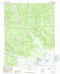
1987 Map of Cimarron
USGS Topo · Published 1987About this map
Philmont Scout Ranch dominates this landscape in northern New Mexico, where the high desert meets the canyon-cut terrain of the Beaubien and Miranda Grant (Maxwell). The town of Cimarron sits at the confluence of the Cimarron River and Ponil Creek, serving as a central hub for the surrounding backcountry camps. Notable sites like Indian Writings Camp, Dean Cow Camp, and Turkey Canyon Camp are connected by a network of 4WD tracks and trails through the rugged north and south forks of Ponil Creek. The presence of an Old Railroad Grade and a Gravel Pit near French Lake points to the area's industrial and transportation history, while the Rodeo Ground and Athletic Field reflect the local culture of the town site. Topographical features like Slate Hill and Antelope Mesa define the southern reaches of the quadrangle.
Find a feature on this map
32 named features on this map. Tap any name to fly to it.
Don’t see what you’re looking for? This feature index may not catch every label — zoom into the map to look around manually.
Map Details
Editions of this 1987 Cimarron Map
This is the sole edition of this map. No revisions or reprints were ever made.
Other maps of this area

1954 · Raton
USGS Topo · 1:250,000

1955 · Cimarron
USGS Topo · 1:62,500

1955 · Ute Park
USGS Topo · 1:62,500

1956 · Tooth Of Time
USGS Topo · 1:62,500

1956 · Miami
USGS Topo · 1:62,500

1958 · Raton
USGS Topo · 1:250,000

1981 · Springer
USGS Topo · 1:100,000

1981 · Raton
USGS Topo · 1:100,000

1982 · Wheeler Peak
USGS Topo · 1:100,000

1983 · Taos
USGS Topo · 1:100,000