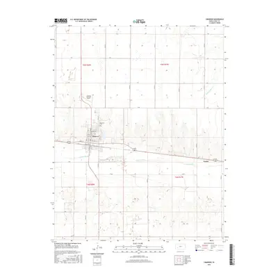
2016 Map of Cimarron
USGS Topo · Published 2016About this map
Cimarron sits prominently along the northern bank of the Arkansas River in this 2016 survey, serving as a hub for the agricultural plains of Gray County. The town's grid is well-defined by historic thoroughfares like Court Ave and Canal Ave, reflecting a community built around the vital water resources and transportation corridors of western Kansas. To the north, the Cimarron Municipal Airport and the Cimarron Cem mark the edge of the residential area before the landscape transitions into an expansive network of section roads. The map reveals the local dependency on these systematic county roads, such as Co Rd 18 and Co Rd 19, which facilitate movement between the main settlement and smaller outposts like Wettick. In the northeast corner, the drainage of S Fork Buckner Cr provides a subtle contrast to the prevailing flat topography.
Find a feature on this map
36 named features on this map. Tap any name to fly to it.
Don’t see what you’re looking for? This feature index may not catch every label — zoom into the map to look around manually.
Map Details
Editions of this 2016 Cimarron Map
This is the sole edition of this map. No revisions or reprints were ever made.
Other maps of this area

1892 · Dodge
USGS Topo · 1:125,000

1955 · Dodge City
USGS Topo · 1:250,000

1958 · Dodge City
USGS Topo · 1:250,000

1959 · Dodge City
USGS Topo · 1:250,000

1968 · Cimarron NW
USGS Topo · 1:24,000

1968 · Ingalls
USGS Topo · 1:24,000

1968 · Dodge City NW
USGS Topo · 1:24,000

1968 · Montezuma NW
USGS Topo · 1:24,000

1968 · Cimarron
USGS Topo · 1:24,000

1968 · Cimarron NE
USGS Topo · 1:24,000